Wednesday, July 28, 2010

Road Trip 2010: Day 50: Whitehorse

An easy day today. Very little group activity scheduled--just a leisurely boat ride on the MV Schwatka. Folks had time to finish up rig repairs, laundry and grocery shopping this afternoon or just laze around.

MV Schwatka can handle 40 passengers
with the captain & crew totaling two.

Schwatka Lake

The lake created by the power dam is approximately 60 feet deep at the dam and shallower as you head upstream. In Miles Canyon it is now approximately 25-30 feet deep. Before the dam, this--and the rapids just below the dam--were the most treacherous stretch of water on the way to the gold fields in Dawson City. Today, the dam has made this a relatively smooth piece of water...although it does do some swirling about in the canyon and the velocity there can make you pay for a mistake real fast.

Alternate means of transportation to be found on Schwatka Lake.

Entrance to the canyon as you leave the lake.

Miles Canyon from up on top.

Canyon walls are volcanic rock.


Volcanic rock makes up the canyon walls.

Volcanic rock makes up the canyon walls.

Foot bridge over Miles Canyon and the Yukon River

For a time in the early 1900s this was the ONLY bridge over the Yukon River. Today there are a few other foot bridges in Whitehorse, one auto bridge in Whitehorse (we took it to go to the fish ladder), one just north of Carmack on the Klondike Highway, and the one on the Dalton Highway we crossed last week. I believe that's the total: Three auto bridges and two or three foot bridges over a river that runs over 2,000 miles. And we've driven across two of the three Yukon River auto bridges during the last week.

"Captain" Hull commands the MV Schwatka

On the way back down to his dock, the Schwatka's captain passed the reins over to the youngest member of our party: Captain Hull.(What an appropriate name for a sailor!) We expressed full confidence in the new commander but were secretly pleased that the "real" commander 1) didn't pass on control until through the canyon and back on the lake and 2) remained nearby so as to retake control should our young man get a swelled head. (The questions about strawberries and palm trees, the playing with a handful of ball bearings, the repeated cries for "Mr. Christian!" didn't shake my confidence in Jonathon at all.)


And that was our morning. Terry and I spent the afternoon doing laundry and going into town to revisit The Canadian Super Store for a few grocery items.

Tomorrow we head back south toward Watson Lake to Nugget City. It will be a long 250-260 mile day so don't expect many photographs.

Road Trip 2010: Day 49: Whitehorse

Today was a semi-free day for our group. We had all day to do as we pleased but then had a group steak dinner at the camp ground in the evening.

Terry and I slept in...all the way until 7:30 AM! Then, after a breakfast of eggs and sausage links, I went and tried to wash the truck. One loonie (a dollar) would get me 3 minutes on the hose. I put in two and set it on wash. Hot soapy water under high pressure took a good deal of the tree pitch off and moved the dirt and grim to new locations on the truck. After I rinsed it the first time and let it dry a bit, I was unsatisfied so got a bucked and brush and deposited another loonie in the wash cycle. Filled the bucket and hosed the truck down again. When the three minutes were done, I "swept" down the truck as best I could and rinsed it off again. It wasn't perfect, but it was better than it was. As someone said who walked by as I was finishing, "You're sure to hit some rain before you get back to Pennsylvania."

After lunch, Terry and I went to town: the Visitors' Center, the SS Klondike, the Fish Ladder, and the McBride Museum of the Yukon.

The women working at the visitors' center were very helpful and we found some interesting information on Yukon activities there. One thing we've learned on this trip is that we should certainly stop at every visitors' center ASAP upon hitting any location that has one.

The SS Klondike is the last wooden paddleboat to ply the waters of the Yukon River between Whitehorse and Dawson City. She was retired from service in 1957 after carrying cargo between 1936 and 1952. Her final years were spent hauling tourists.

The SS Klondike

She'd haul 250 tons of cargo and, without a keel,
draw just 36 inches of water.


Her boilers were fueled by cordwood.

Cordwood would be stacked in two long rows, one on each side of the cargo hold. She might burn two cords and hour when fighting the current in some of the more difficult stretches.

Mechanical liner.

This deck mounted device helped pull the vessel through the Five Finger Rapids by means of cables. The cables, sunk in the channel, would be fished out of the water and wound around the capstans. Then the ship could be more easily kept in the center of the narrow channel whether going up stream or down. It beat the heck out of having to have people on the shoreline hand-lining the boat through the narrows!

The ship is set up so as to reflect the way she might have looked in 1936. This included the menu in the dining room and the cargo down in the hold.

Tins of gasoline. Packaged in 5 gallon containers,
two containers to a crate.


Matches, shredded wheat and medicines.

Canned fruits and vegetables.

Powdered milk (KLIM: "Spell it backwards") powdered eggs and sugar.

Bordens Reindeer Milk (Actually sweetened condensed milk.)


After leaving the SS Klondike, we made our way over to The Fish Ladder below the hydro dam to see if the Chinook Salmon (also known as King Salmon) had arrived. No such luck. They've been delayed on their way up the Yukon, perhaps by the very heavy rains that washed out the road up north. We did learn that they expect them next week but that there won't be many of them. (A count done near the US-Canada border confirmed that the numbers are quite low.)

A long, long swim!

To reach Whitehorse, the Kings have to swim nearly 2000 miles up the Yukon River from the Bering Sea.

The Fish Ladder

The ladder aids the fish in getting up the 60 feet necessary to rise above the power dam built by Yukon Energy. It's baffles, and pens made it easy for the fish to swim upstream to the lake above the dam and also easy for the scientists to capture, measure and--if necessary--strip eggs and milt from the fish.

This is the longest (1182 feet) wooden fish ladder in the world.

Yukon Energy Dam

Then it was back to the center of town to visit the MacBride Museum of the Yukon.

They had lots of interesting artifacts of the gold and silver and copper mining rushes that took place to the north. Including Sam McGee's original cabin.

Sam McGee's cabin.

Yes. He was a miner but he staked his claim in copper, not gold, and made a pretty penny on it, too. And no, he was not from Tennessee, but from Ontario and he claimed to have actually liked the cold, returning to the Dawson City area after a stint in California. And yes, he did know Robert W. Service, postal clerk, who liked the sound of his name so much he asked if he could use it in a poem.

Canada's Red Ensign

The Red Ensign was Canada's official flag until 1965 when she switched to today's red and white vertical stripes with the red maple leaf in the center. We saw one flying over the SS Klondike but didn't recognize it. Luckily, the museum explained it all.

The Red Ensign explained.


As 5 PM approached we headed back to the campsite outside of town and enjoyed a nice steak dinner with our "family."

Tuesday, July 27, 2010

Road Trip 2010: Day 48: Destruction Bay to Whitehorse

We left Destruction Bay on Monday under much better conditions than we did on our way north. Then the wind had died down and the rains had begun...the same rains that would eventually wash out the Top of the World Highway between Chicken and the border. This time we had beautifully clear skies and a light wind (more than a breeze but certainly not a gale!) and temperatures that would eventually reach the low 70s as we approached Whitehorse.

And the road was much better than that stretch that bridges the border between Tok and Destruction Bay.

Terry and I did stop briefly in Haines Junction so she could look at the Millennium Quilt hanging in the town hall. I didn't go inside but snapped pictures of the mountains above town while I waited.

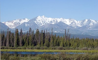
Mountain scene between Kulane Country and Haines Junction.

Mountain scene between Kulane Country and Haines Junction.

Mountains above Haines Junction.

Mountains above Haines Junction.


Mountain scenery between Haines Junction and Whitehorse.

Kluane Ranges from south of Haines Junction.
(Look at the snow capped peaks in the cleft of
the mountains in the foreground.)


What do you think?

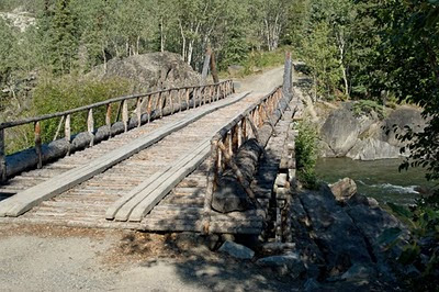
The Canyon Creek Bridge

The bridge is on the National Historic Registry as part of the original Dalton Trail from Skagway to Dawson City

The Canyon Creek Bridge

"The bridge does not meet current highway code." Really?

There was a "Bannock Stand" adjacent to the parking lot at the bridge and you could purchase "fresh bannock". Terry got one piece of fried and one piece of baked from the young man (First Nation) at the stand. It may not have been fresh, having been cooked the day before, but it was certainly delicious!

We continued on our way to Whitehorse and pulled into a very crowded campground. There were three other caravans there besides ours. And we were a day earlier than our original itinerary so we were shoehorned into the empty slots where ever they might be.

(All three of the caravans would leave the next morning, but we would be staying for three nights.)

Road Trip 2010: Day 47 Tok to Destruction Bay

Originally, we were supposed to leave Tok and head north to Chicken and Dawson City. The rains changed all that when they washed away much of the road between those two towns. The road has been closed indefinitely and there's some concern for the folks trapped between washouts. At least four lives have been lost and Alaska's Governor Parnell has (according to Rev. Paul) declared the highway a disaster area.

So, in retrospect, it's a good thing we have been rerouted to Destruction Bay and then Whitehorse. We would have been in Whitehorse again anyway as we came out of Dawson City, but we're here a day earlier than expected.

The road from Tok to Destruction Bay wasn't any better than when we went in the opposite direction. Perhaps it was even a bit worse. Lots of frost heaves, ruts and pot holes meant slalom city and slow speeds and lots of "yee-ha!".

Still, with clear skies and sunshine, the scenery was grand. We stopped at the Tetlin National Wildlife Refuge again to see how Cora was making out with her beading. Otherwise, all our stops were brief ones.

View twixt Tok and Tetlin

View twixt Tok and Tetlin

Tetlin NWR entry door

Some of Cora's beadwork on mitten of
elk hide trimmed with dyed beaver


Cora's work on moccasins and mittens

Cora at the Tetlin Visitors' Center.

Not only is her beadwork excellent, she provided information about Top of the World Highway closure and activity. When we expressed disappointment at not getting up that way, she smiled and said, "Now you have a reason to come back! But hurry. I retire in two years!"

View from the Tetlin Visitors' Center deck.

View from the Tetlin Visitors' Center deck.

Model of a cache at Tetlin NWR

Tetlin Visitors' Center with sod roof.

Sod roofs are excellent insulators in the winter and coolers in the summer. They just do not last that long. Just 5 to 10 years for sod versus 20 for shingles or 30-50 for metal.

Kluane Ice Fields are j-u-s-t over the top.

Burwash Landing

Home of the world's largest gold pan. This baby is at least 12 feet in diameter.

We ran into a family heading north in a small SUV. Scrawled on the rear window was Fairbanks Alaska or Bust! A young couple with four little kids in tow the SUV had New Jersey plates so we inquired as to where they were from. SHE was full time Air Force and, after serving a stint at McGuire AFB in NJ--her home state, was headed up to the Eielson Air Force Base for the next three years. He looked like he could have played football or substituted for a grizzly bear. The kids ranged in age from around 3 up to 9 or 10. We wished them well and gave them some hints as to what they might do for entertainment and activities with the brood. We also hoped they brought some warm clothes with them.

Then it was back to Destruction Bay for the night. At least this time the wind was well below the gale we had last time we arrived.

Road Trip 2010: Day 46: Fairbanks to Tok

We departed Fairbanks/North Pole early on the morning of the 24th under clearing skies that soon became azure blue. Our destination for the day: Tok, AK, the only town a ground traveler must pass through twice when visiting the main portion of Alaska. There is no other highway that crosses the boarder.

A short distance out of North Pole, we passed Eielson Air Force Base...which is huge! Odd part is, there was a line fighter jets on the runway and another of five bombers and no signs on the highway. A half mile down the road (and still alongside the runways and hangers) there were signs posted warning there could be no stopping and no photography.

A bit further south and the Alaskan Range once again came into view.

Is that McKinley off to the west?

Mount Deborah to our south.

Snow capped Hayes, Hess and Deborah glint in the sun.


The pipeline still paralleled our path and when we crossed the Tanana, it too had to cross...via its own suspension bridge.

The pipeline gets suspended over the Tanana

Schematic of suspension bridge

Construction and maintenance of the pipeline require(d) thinking outside the box.


We continued south on the Richardson to the town of Delta Junction.

Delta Junction: Northern Terminus of Alaskan Highway: MP 1422

Wooden plaque on Highway Construction

A life size model of Alaskan Mosquito.
(Or so I'm told. They were pretty mild while we visited.)


Bison warning sign


Comparison of VIPs: "Very Important Pipelines"

Heading south to Tok, we came upon a very kitshcey roadside attraction. While we went in and signed their guest book, we passed on paying the $9 each to walk around. It could have been a great, hokey sorta place with a little more maintenance, but it appeared sadly run down.

Mukluk Land