Friday, September 09, 2016

Canadian Maritimes: Nova Scotia (the southern part) (Part 2)

Our second day in Nova Scotia we took it easy. We traveled over to the river to watch the tide come in. There were a few other couples there--from Ohio, Iowa and Indiana, I believe. I suggested we have a Big Ten meeting since Terry and I went to Rutgers but now live in PA so we represented 5 of the 12 teams in the Conference.

The tidal bore along the river in Truro is somewhat famous. They've got lights so you can watch it at night and park benches so you can get off your feet while you wait. There's even a small interpretive/information building.

While the total change isn't as great as out in the bay, it's still kind of cool to watch the water flow upstream. We were there during a neap tide period (that's the slowest of the high tide) so we only got to see about a 6-8 inch wave come up the creek.

Waiting on the tide to come in.

Here it comes!

And comes and

comes some more.
It's like watching waves wash up on the beach BUT NEVER GO BACK DOWN. Like shoving 6-8 inch sheets of chocolate covered styrofoam on top of one another over and over again.

Eventually all the brown soil would be covered with water. Amazing.

Then we went back to the camper and did laundry and jumped in the pool.

Canadian Maritimes: Nova Scotia (the southern part) (Part 1)

We planned a three night stay in Truro with the idea of exploring the south end of Nova Scotia and possibly even getting over to Prince Edward Island. (The latter never happened.)

After checking into the Scotia Pines Campground (much easier to find!), we had plenty of time to head down toward Halifax on the southeast coast. We were heading toward the British stronghold known as the Citadel.

It's a massive stone edifice sitting atop a hill overlooking downtown Halifax and the entrance to Halifax harbor. But it wasn't constructed to protect the harbor, according tour tour guide. That job belonged to smaller island stationed batteries. The Citadel was to protect from land invasions from the north. It was so large and so strong that the British would give guided tours for the emissaries from France and the newly formed US. They would point out its strong points and brag about how they would be able to cut down any attempt at taking the fort. And it is an impressive system built for killing--no--annihilating any army foolish enough to try to scale it's walls. The cross fire from the walls, the height of the walls themselves, the pit between the outer and inner walls, the long, steep slopes leading up to the outer walls which could be covered by cannon firing grapeshot... Let's just say any attacker might get close but never close enough.

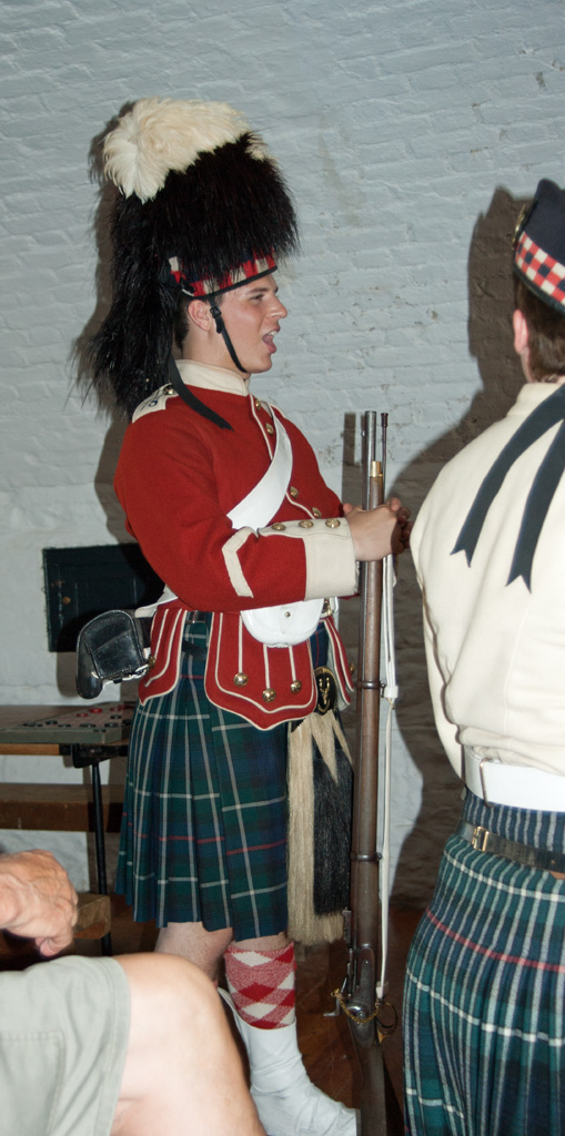
Oh, and it was manned by a Scottish Regiment. Who in their right mind wants to fight a bunch of guys wearing knee socks, skirts and a bear on their head!? Especially when they break out the bagpipes!!!!


Parade ground of The Citadel

Parade ground of The Citadel

Parade ground of The Citadel. The flagpoles here would carry information about ships arriving and departing the harbor.


 The place is HUGE!

One of the cannon on the wall.

Our tour guide.

Soldier dressed for duty. Yeah, it's all wool. And it was 90 degrees F. Poor bastard.

Standing guard.

Just a reminder: This was a British fort.

More cannons aimed down the slope.

Armory and storage facilities.

Changing of the guard at the main gate.

Changing of the guard at the main gate.

Panorama from the walls.

Afterward, we were going to go down to the waterfront and walk the newly refurbished boardwalk, BUT it was a Friday and there was a jazz festival going on and everyone in the southern parts of Nova Scotia were there. We could not find a parking spot for the Tundra and so slowly made our way up the eastern shore heading for our campground.

Along the way we found a little hole-in-the-wall place that made the best fish and chips we had on the trip.

Canadian Maritimes: New Brunswick

After locating our campground--not as easy as it sounds!--It was much further from the Fundy Park than I thought.--we went out to dinner in what may have been the only restaurant for miles and miles around. We were the only customers for the first 45 minutes we were there. But their scallops!?! To die for!

The next day we drove east to visit the Bay of Fundy National Park where, after paying for our park pass, we did a little exploring.

There was one site where the Point Wolfe River ran down into the Bay. At one time there had been a dam and a mill here. Now there's just a little covered bridge, the remnants of the dam and a very stony beach. Still, it was a pretty place to stop and get our first close-up of the Bay of Fundy while walking on the stones that would soon be covered as the tide turned.

Looking from the beach to the Bay of Fundy.

Terry standing by one of the many, many rock cairns erected on the beach.

Covered Bridge over the Point Wolfe River.

Site of the mill dam on the Point Wolfe River.

After our brief stop here, we motored further north along the coast to the Hopewell Rocks.

The rocks are the remnants of eroded conglomerate along the coast. They stand tall and proud at low tide but are nearly covered by water at high tide. The Bay's waters can fluctuate by as much as 30-40 feet in a 12 and a half hour cycle! We got there at low tide and got to walk on the beach.

Looking down from atop the cliff. That's the Bay of Fundy and Nova Scotia in the distance.

From the beach, you get the feel for how large the rock formations are.

And the beach isn't flat, either. It's quite steep going down to the water.

Put some people into the frame and you can see how high the cliffs are.

Another view along the beach.

There's a nice, steel and concrete stairway to get down to the beach. With 101 steps!

Another view of the cliff face.

Terry had to go down to the water's edge to touch the Chocolate River, as the Bay of Fundy is called. The huge, rapid change in the tides create quite a current and lots of turbulence grinding away at the sea floor and all the sand and rocks become powder which then get suspended in the ever moving water.

One more view of the undercut rocks along the beach.

They become somewhat mushroom shaped over time. The one on the left looks like it may be submerged during high tide--nothing growing on top.

Occasionally you get a natural bridge like this.
There are several rangers on the beach to answer questions--and keep an eye on the time. They will let you know when the tide is turning and when you must make your way up those 101 steps pronto.

Having had our fill, we moseyed on back to our campsite for the night. The next day we would be heading to Truro, Nova Scotia.

Down East and the Maritimes: Bar Harbor Cruise

I've been remiss in posting pictures of our three-week trip to the northeast. I've an excuse or two but lets say it was mostly exhaustion and let it go at that.

After watching the sun rise from Cadillac Mountain, Terry and I went down into Bar Harbor to have breakfast and then get ready for our nature cruise which we had booked the day before.

While we waited for our boarding time, Terry made a friend on the pier.

You could opt for a cruise on this schooner.

Two of the motor cruisers,  The smaller one on the left goes way out looking for whales.

Our ride awaits.

One of many beautiful coastal homes.

I wouldn't mind living here!

Bald Eagle watches us go by.

Cormorants and Gulls abound.

Rocky shores of Acadia.

Thunder Hole from the water.

There were plenty of seals out on the rocks.

Plenty of them.

One of many lighthouses on the Maine coast that have been automated. Must have been a grand--if harsh--life for an introvert.

Another Bald Eagle watched us from the shore.

And not to far away, this Peregrine Falcon sat in the tree top.
After seeing the Peregrine, we cruised on back to the dock and debarked.

The next day we departed the Bar Harbor area and headed north into Canada's New Brunswick Provence and the Bay of Fundy National Park.

Tuesday, July 12, 2016

Down East and the Maritimes: Day Five (Part 1)

We started our day at the early time of 3:00 AM. Our campground is about 40 minutes from the Cadillac Mt. turn within Acadia National Park so we figured to give ourselves plenty of time to get to the summit for the 4:59 sunrise. Well, as should have been expected, there was no traffic at 3:15 in the morning and we zoomed right along arriving at the summit at about 3:45. We weren't first, but we were in the first dozen cars in the lot. That would continue to change as the minutes ticked away.

We found ourselves a comfortable rock with some plant growth directly in front of us--thus giving no one a chance to block our view--and settled down in a chill breeze to wait.

Color began to appear in the sky quite early as a low bank of clouds began to reflect pink, purple and orange from the approaching Sun.
Lightening sky to the northeast at 0425
Minute by minute the color became more intense.
Color to the northeast at 0428.
And the crowd began to swell. The parking lot filled and folks parked on the road and/or in the middle of the parking lot blocking everything.
The sun was scheduled to appear over the horizon at 0459 and it seemed it was going to wait to the last second. But meanwhile it would tease.
Still no Sun at 0457
And then...MAGIC!

The first sliver peeped above the horizon right on schedule. (Some people did not. They were late to the party.)
First sliver of sun at 0458 and a smidge.